Stone Arch Bridge over the Mississippi River
Minneapolis, Minnesota, USA
Every time I cross the Mississippi River on I-35W, I thrill to get a glimpse of The Stone Arch Bridge – a Minneapolis icon. It is truly unique to our city, and a timeless piece of architecture and history. Built in 1883, it connected rail lines east of the Mississippi River to downtown Minneapolis. It became the city’s most important and impressive railroad bridge.
James J. Hill built the 2,100 foot Stone Arch Bridge to improve passenger train access to downtown Minneapolis. With the sweeping curve at its west end, the bridge is a unique example of skilled masonry construction. In 1974, it was named a National Historic Civil Engineer Landmark. (Why the sweeping curve? See “Questions” below!)
Today, visitors to the area are encouraged to utilize the Heritage Trail which includes crossing the river on the Stone Arch Bridge and circles the St. Anthony Falls from all sides. It provides stunning views of the river from a variety of vantage points.
The Stone Arch Bridge was our starting point on our recent Travel Date as we continue to explore the wonderful Minnesota sites in our back yard.
The Stone Arch Bridge
Experiencing the Stone Arch Bridge also means experiencing the Falls of St. Anthony. Today it is not actually a falls, but rather dam. The bridge – and the falls – are the focal point of the Mississippi River in this area.
View of the Stone Arch Bridge
P.C. Cher B. 9/18/21
In 1879, James. J. Hill, St. Paul railroad magnet, opened his “Manitoba line” to the Canadian border. This railroad linked the wheat fields of the Red River Valley (northeast Minnesota/North Dakota) to the flour mills of Minneapolis.
The Stone Arch Bridge improved passenger train access to downtown Minneapolis.
Architecturally, the bridge was highly significant. Most railroad bridges were built of iron, but the Stone Arch was built to be sturdy and long lived. Built of native Minnesota granite and limestone, it is said to be “more solid than the ground itself.” Time has proven this to be true. Fortunately, it is also aesthetically pleasing as well!
View from the Stone Arch Bridge

P.C. Cher B. 9/18/21
Stone Arch Bridge: On the Heritage Trail
The Stone Arch Bridge was our starting point as we began our Travel Date of the Mississippi River Heritage Trail heading from St. Anthony Main toward downtown Minneapolis.
This view off of the Stone Arch Bridge offers a great vantage point for the visitor to get acclimated to what is ahead on the Heritage Trail.
P.C. Cher B 9/18/21
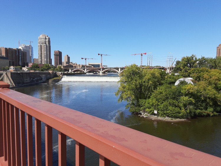
On the far left is downtown Minneapolis and the St. Anthony Falls Lock, the falls are in the center, and on the right is a part of Hennepin Island, detailed on another blog. The 3rd Avenue Bridge (currently under reconstruction at this posting) is in the back.
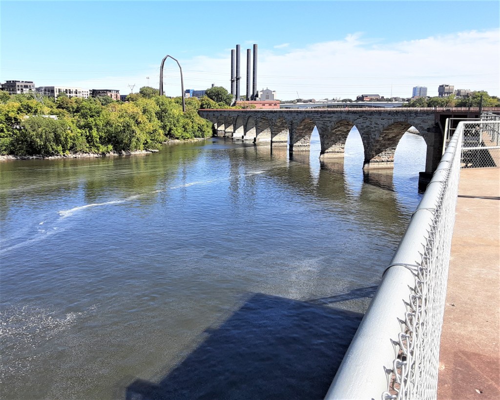
The Stone Arch Bridge – 2100′ long and 28′ wide, with 23 arches – provides great views of St. Anthony Falls.

P.C. Skip B 9/18/21
The Stone Arch Bridge is a statement of the Twin Cities’ importance as a railroad hub. This made it able to lay claim to an expansive hinterland. Control of railroads meant control of commerce, and rail links consolidated the Twin Cities’ prosperity in the 19th century. They were also a key ingredient to the flour industry – linking wheat from farms, to mills, and to eastern markets.
For our Travel Date, we began with the Stone Arch Bridge, entering through Pillsbury Park off of St. Anthony Main.

P.C. Cher B 9/18/21
Remnants of the old rail lines are evident on the bridge today. Multiple rail lines used the tracks that curved across the bridge into Minneapolis’ Union Station.
Stone Arch Bridge: for Visitors
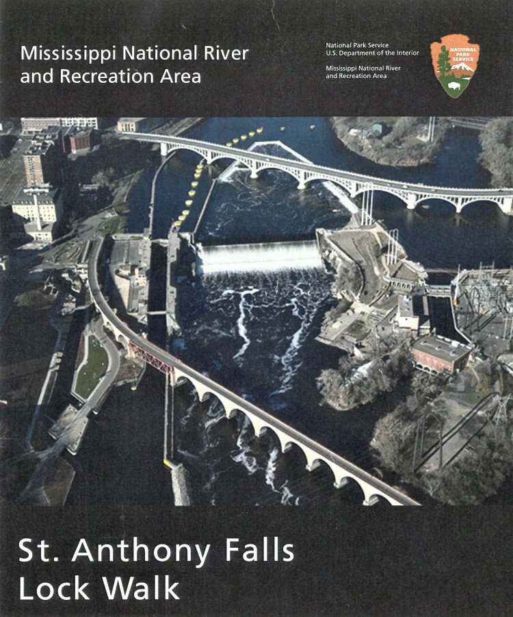
This helpful brochure was available at the staffed booth just at the entrance to the St. Anthony Falls Lock. I don’t know when it is staffed, but I’m sure if you contact the National Park Service, they can see you get a hard copy or PDF online. It was an invaluable resource of information.
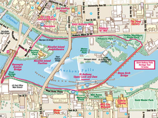
The Stone Arch Bridge can be seen at the bottom of the photo (left). On the map (right), the bridge is on the right side with the red line spanning the Mississippi River. The red line diagrams the Heritage Trail.
On our Travel Date, we followed this trail, exploring and discovering as we went. It was a great adventure on a gorgeous Minnesota September day!
The Heritage Trail circles the falls from all sides, providing an easy-to-follow path with stunning views of the river from a variety of vantage points.
Both of these images provide a good look at the configuration of the current falls, how it lines up with the Stone Arch Bridge, and the paths that connect points of interest and how to cross the river.

P.C. Cher B 9/18/21
Where to Start: You can start at any point along the Heritage Trail that is convenient or interesting to you. We worked backward from our schedule considering free parking options and where we wanted to end our day.
Pillsbury Park, St. Anthony Main area, was our starting point, by the north end of the Stone Arch Bridge, was perfect for us because we wanted to end our day at The Astor, a favorite outdoor cafe in that area. (And we found free on-street neighborhood parking only a few blocks away. YAY!).
If you are coming from downtown or NE Minneapolis, then you’d want to start at those points. Heritage Trail is flexible to fit for your wants, needs and schedule!
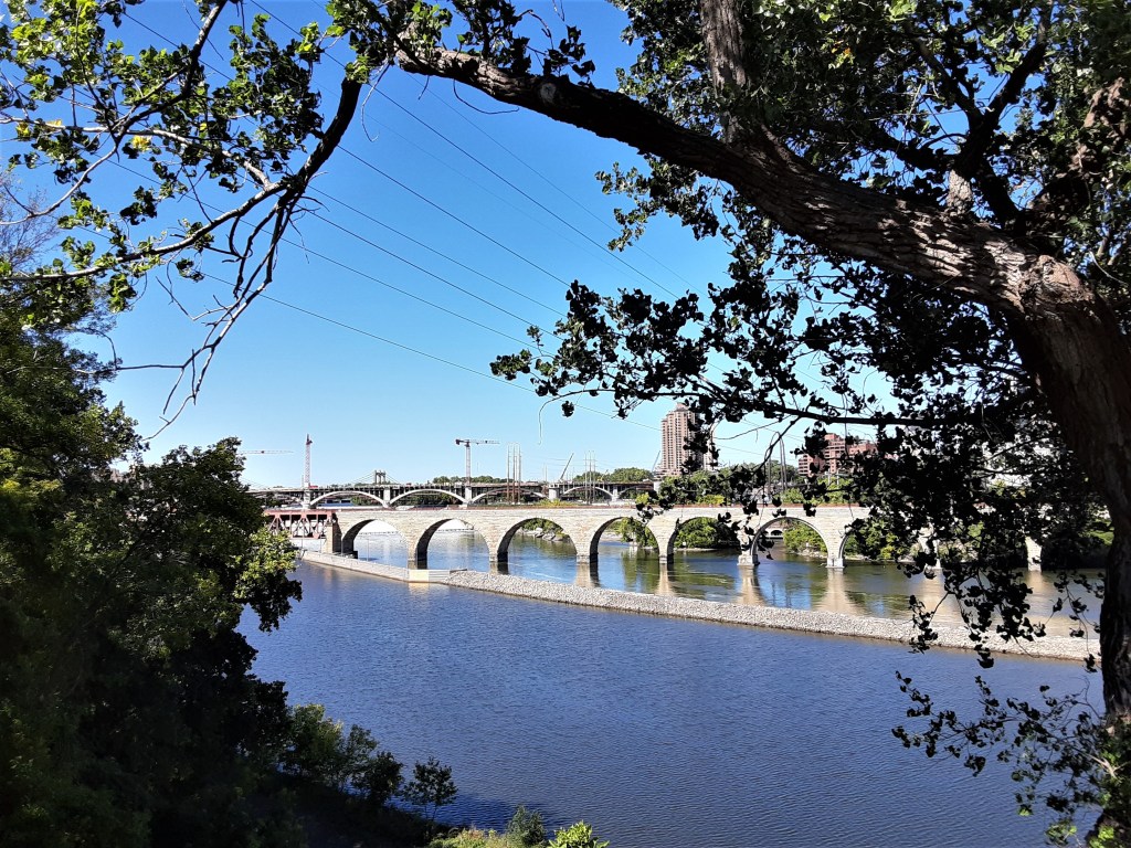
Stone Arch Bridge: Views Today
We enjoyed the great views of the Stone Arch Bridge as we explored the sites along the eastern route of the Heritage Trail.
Stone Arch Bridge: View from the St. Anthony Falls Lock Park
P.C. Cher B 9/18/21
Stone Arch Bridge: View from the Guthrie Theater

P.C. Cher B. 9/18/21
Stone Arch Bridge: View from the 35W Bridge Memorial

P.C. Cher B. 9/18/21
Stone Arch Bridge: Views from History
Always curious what things looked like “back then”. . . I did some digging. The Stone Arch Bridge as seen in art and history is informative – and fascinating! I discovered a photo of the bridge with an actual train crossing it. The Mia (Minneapolis Institute of Art) has two great pieces of art including the bridge. I always include them on my Minnesota Art History tours – of course!
Stone Arch Bridge: In Action
I like to imagine generations of immigrants and visitors as they got their first view of Minneapolis from the window of a train crossing the Stone Arch Bridge!
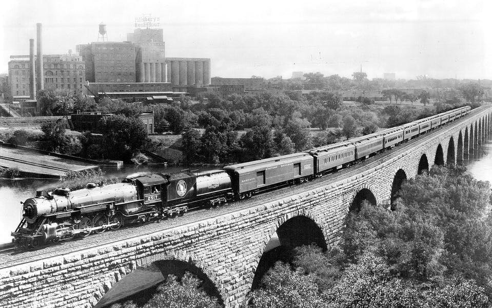
I enjoy discovering old photos such as this which show the bridge when it transported railroad trains vs. the walkers, joggers and bicyclers of today! I commend the foresight of the planning committees who made the transition to public use a reality.
Created by Tiffany & Company, New York, this elaborate silver presentation tray (on right) was given to James J. Hill on September 10, 1884, by the citizens of Minneapolis.
The tray honored Hill’s “work, character, and career in the Northwest” and commemorated the recent completion of the Stone Arch Bridge, which allowed passenger transportation across the Mississippi River into the city.
It is packed with sites we saw on the Heritage Trail, engraved with a view of Minneapolis in 1884. The Stone Arch Bridge (center), the Washburn flour mill (on left), and the Pillsbury flour “A” mill (on right) are included.
The Hennepin Avenue Bridge is upriver. To its left is the Minneapolis Union Depot. This depot was part of Hill’s development of rail service in the city.
Scenes of events from Hill’s career are in the border, culminating in a portrait medallion of Hill at the top. Separating these are six trophy heads of animals native to the Northwest Territory: elk, buffalo, Rocky Mountain sheep, deer and wolves.
Stone Arch Bridge: in Art

This magnificent tray – 33 5/8″ wide x 29″ tall x 3 1/4″ deep – can be seen today at the Mia (Minneapolis Institute of Art). Check the website for room – artsmia.org.
Stone Arch Bridge: My Ancestral Views

One of the things I enjoy about art is that one can step back in time and view places in history that are no longer visible. The booming young city of Minneapolis can be seen simply by viewing the naturalistic paintings of Minneapolis by Alex Jean Fournier, local American artist born in St. Paul.
“Mill Pond Minneapolis” by Fournier (painting on left) was the first painting I discovered of the St. Anthony Falls and the Stone Arch Bridge at the Mia (Minneapolis Institute of Art).
It was the date – “1888” – that caught my attention!
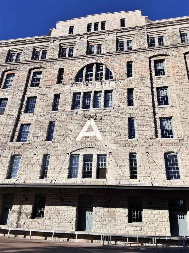
This painting, completed in 1888, has a special place in my heart. My great-grandparents and their 5 children (including my grandfather), immigrated from Sweden to Minneapolis in 1888. They lived on the flats of the Mississippi River for several years before moving to a farm in central Minnesota.
My great-grandfather worked at the Pillsbury “A” Mill (photo on right) on the opposite side of the river from this painting. It is fun to think that this view of the falls area was what he saw as he went to work in 1888!
P.C. Cher B. 9/18/21
Stone Arch Bridge: Some Questions
Why are Stone Arches Missing? Why is the Bridge Curved?
Why are there trusses on part of the bridge where stone arches were removed?
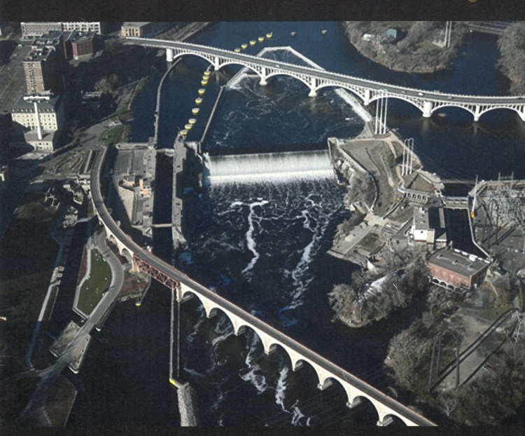
This is one question that has intrigued me. The reason becomes very clear from an aerial view as seen on this photo – the Lock and Dam.
1961- 1963 – The lock and dam was built at St. Anthony falls which required arch number 13 and 14 (of the 23 original arches) to be replaced with a 200-foot Warren truss and allow barges to pass.
Of course this was no longer necessary when the lock closed down in 2015, but sadly, the deed was done.
Why is the bridge curved and not straight across the river?
We enjoy its aesthetics, but the reason for the curve is much more practical. The wise engineer was wary of disrupting the sandstone riverbed above the falls — which was already eroding — and perhaps fundamentally altering the water power fueling the city’s industry. A catastrophic collapse caused by the construction of a tunnel a dozen years earlier was still fresh in people’s minds. They were also worried about the bridge’s pillars creating ice and logjams above the falls. Playing it safe, they built the bridge below the falls, crossing at a diagonal – with a six degree curve at one end. Trains could easily travel into the riverside rail yards on their way to and from the proposed depot.
From Curious Minnesota, Eric Roper Star Tribune 11/2/19) -startribune.com/why-does-the-stone-arch-bridge-cross-the-mississippi-at-such-an-odd-angle/561251221/
The Stone Arch Bridge is a place filled with memories – and to make new ones. It has been the site of countless marriage proposals. It is a place where locals take out-of-town guests to show off our fair city. For Skip and me, it was the starting point of a wonderful Travel Date where we explored the sites and views along the Mississippi River Heritage Trail and enjoyed each other’s company on a splendid Minnesota September day.
Blogs on this fun adventure have been divided into several units: Nicollet Island, St. Anthony Falls, Guthrie Theater, Hennepin Island, St. Anthony Main, Mill Ruins Park and a future visit to the Mill City Museum.
Sources
- All photos by Cher B or Skip B unless otherwise noted.
- Self-Guided Tour by Cher B with Skip B. 18 September 2021
- Brochure: “St. Anthony Falls Lock Walk” Mississippi National River and Recreation Area. National Park Service. US Department of Interior
- Minneapolis Institute of Art: artsmia.org
- Star Tribune Curious Minnesota: Roper, Eric. Curious Minnesota, Star Tribune 11/2/19) -startribune.com/why-does-the-stone-arch-bridge-cross-the-mississippi-at-such-an-odd-angle/561251221/
